

Texans who rely on water resources—whether for agriculture, flood planning, or recreation—often search for “LCRA Hydromet” to access real-time weather and streamflow data. The Lower Colorado River Authority’s Hydromet system is a comprehensive, web-accessible tool that tracks rainfall, stream levels, river flows, reservoir conditions, and weather across Texas. In 2025, this system has become more critical than ever, helping communities plan ahead, conserve water, and stay safe during extreme weather.
This article breaks down everything you need to know about the LCRA Hydromet system: its tools, data accuracy, how to use it effectively, and why it’s an indispensable asset for Texans.
What Is LCRA Hydromet?
The LCRA Hydromet (Hydrological Monitoring System) is a real-time environmental monitoring network operated by the Lower Colorado River Authority. It collects, stores, and distributes data from over 275 automated sensors located throughout the Colorado River basin and other major watersheds in Texas.
What it monitors:
- Rainfall (daily, hourly, cumulative)
- Stream and river levels
- Reservoir storage levels
- Soil moisture and air temperature
- Wind speed, humidity, and barometric pressure
The system is used extensively by emergency managers, farmers, city planners, engineers, and outdoor enthusiasts to make informed decisions about water use and public safety.
Who Operates LCRA Hydromet?
LCRA (Lower Colorado River Authority) is a public nonprofit agency created by the Texas Legislature in 1934. While it operates without tax funding, it manages water resources across more than 600 miles of the Colorado River.
LCRA’s responsibilities include:
- Managing the Highland Lakes (Lake Travis, Lake Buchanan, etc.)
- Delivering wholesale electricity
- Protecting natural resources
- Operating flood management systems, including Hydromet
Hydromet is maintained and developed in-house by LCRA’s technical team, which includes hydrologists, engineers, software developers, and environmental scientists.
How to Use LCRA Hydromet
Website Access:
Key Features:
- Map-based interface with zoom
- Filter by location or station type (rain gauge, stream gauge, etc.)
- Exportable data charts
- Historical records for comparison
User Tip: If you’re tracking a specific location (like your farm or a favorite river spot), you can bookmark individual station URLs or download real-time data feeds via CSV.
Real-Time Weather & Stream Gauges
Hydromet updates its data every 15 minutes from hundreds of gauges across Central Texas.
Gauges you can monitor include:
- Rainfall Totals (e.g., daily totals in inches)
- Stream Flow (in cubic feet per second, cfs)
- Lake Elevation & Volume
- Reservoir Inflows/Outflows
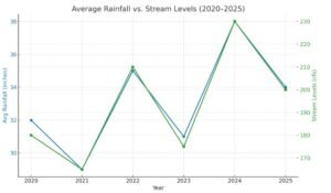
These readings are critical during flash flood risks or severe drought periods.
How Accurate Is LCRA Hydromet?
Hydromet uses scientific-grade sensors regularly maintained by LCRA crews. The system is known for:
- Redundancy: Some stations have backups for rainfall and pressure sensors
- Cross-verification: Field visits verify unusual readings
- Data smoothing: Reduces anomalies from storm noise or wind spikes
In emergency response or permitting situations, Hydromet is often preferred over generic weather apps due to its hyperlocal accuracy.
Who Uses Hydromet and Why It Matters
- Farmers:
Plan irrigation schedules based on real rainfall, not forecasts.
- City Planners:
Design stormwater systems using historical flood data.
- Emergency Services:
Monitor rising creeks in real-time to issue flood alerts.
- General Public:
Track lake levels before planning boating or fishing trips.
- Environmental Scientists:
Study long-term weather and water patterns.
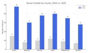
LCRA’s Network of Sensors (2025 Map Overview)
As of 2025, Hydromet supports:
- 275+ active stations
- 40+ counties covered
- 8 major rivers and tributaries monitored
📍 Most monitored counties: Travis, Bastrop, Burnet, Llano, Williamson, Fayette
Data Types You Can Download from Hydromet
Hydromet offers public access to:
- Rainfall (in hourly, daily, cumulative formats)
- Water level height & volume
- Flow rates (cfs)
- Weather (temperature, wind, barometric pressure)
Formats supported:
- CSV (Excel compatible)
- Real-time feed API for developers
Great for academic research, reporting, or predictive analytics models.
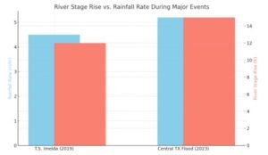
How Hydromet Helps During Emergencies
During major floods, like those caused by Tropical Storm Imelda (2019) or the 2023 Central Texas Flood, Hydromet played a vital role in monitoring rainfall intensity and river response.
The system integrates with:
- National Weather Service flood warnings
- LCRA River Operations Center
- Public alert systems
LCRA Hydromet and Drought Monitoring
Not just for floods—Hydromet helps manage drought response plans:
- Tracks rainfall deficits
- Assists in Stage 1, 2, and 3 water restrictions
- Supports lake management strategies
The Highland Lakes depend on these insights to prevent water shortages in Austin, Cedar Park, and downstream communities.
Does LCRA Hydromet Have a Mobile App?
Currently: No standalone mobile app.
However, the website is fully mobile-responsive, allowing:
- Real-time data access
- Saved stations
- Graph downloads on smartphones
In 2025, LCRA is rumored to be piloting a prototype app that will include push alerts for select users.
Funding, Costs & Access
Is it free? Yes. Hydromet is public.
Funding sources:
- LCRA’s power revenues
- Water delivery fees
- Federal & state grants (especially for flood mitigation projects)
Annual maintenance cost: Estimated at $2–3 million/year
No login required, though advanced users can request API access for integrations.
Limitations & Alternatives
Limitations:
- Data may be delayed during sensor outages
- No satellite radar layer overlay
- No predictive AI/ML model yet embedded
Alternatives for broader data:
- NOAA/NWS river forecast tools
- Texas Water Development Board drought dashboard
Final Thoughts
Whether you’re a landowner, city engineer, or just a weather geek, LCRA Hydromet offers unrivaled access to Texas’ environmental pulse. From its 15-minute rainfall logs to its stream elevation charts, this system supports everything from irrigation to emergency management.
Its transparency, real-time responsiveness, and public utility make Hydromet one of the most powerful yet underused water data platforms in Texas.
Bookmark it, explore it, and let it empower your next weather-dependent decision.
📍 Official Website: hydromet
📍 LCRA Headquarters: 3700 Lake Austin Blvd, Austin, TX 78703, United States
📍 Public Contact: (512) 473-3200 | info@lcra.org
FAQs
Q1: How often does LCRA Hydromet update its data?
Typically every 15 minutes, depending on the station.
Q2: Can I view historical data?
Yes, most gauges allow access to several years’ worth of data.
Q3: Does LCRA Hydromet predict floods?
No. It provides real-time observations; flood forecasting is done by the NWS.
Q4: Can I use Hydromet data in my research or publication?
Yes, it’s open-source and publicly accessible.
Also read these articles:
6 easy steps help you start a small coffee shop business